© Copyrights 1988, 1990-1999, 2000-2006, 2010-2020 Rankton LLC

Journal 2017 Archive
January 2017
More Feed Out in the ColdSunday 1 January 2017
On Friday, I purchased 200 lbs of feed to throw around. I purchased 100 lbs of oats, 50 lbs of All Stock and 50 lbs of All Flock from Fleet Farm's Sprout brand feeds. Kip and I wondered what the different feeds would attract. We had thrown down some All Stock in the Cabin Meadow two winters ago, and it was eaten up by many different critters. Along with it being one of the coldest days in the past few weeks, the snow was relatively deep, averaging about a foot and half. The undercarriage of the Ford Ranger made troughs on the road. I put All Flock, All Stock and oats near the cameras in the East End, Lenise's Stand and the Oak Meadow. I made 'food troughs' with the tires on the Ranger by driving back and forth in the deep snow. I hoped to acclimatize the deer to the smell of the truck; not necessarily having the deer associating the truck with food, but knowing that when the truck is around, it didn't mean any harm. We're excited to see what the cameras capture.February 2017
Trails Cams with nearly 10,000 imagesSaturday 4 February 2017
We've be sick with what ever is going around. Since I was feeling the better of the two of us, I made the run to swap out memory cards. The cameras had stayed out for over 5 weeks and collected lots of pictures; nearly 10,000 in total. Some of the cameras even registered more images than the SD cards should have been able to hold and yes, that's how many were on the cards. I put out feed, oats, flock and stock pellets, on the 13JAN and it attracted a lot of critters! The Widow Maker Corner camera captured some interesting images. Rankton9, in Roy’s Loop, captured some good images of one of the bobcats. Gallery SnafuWednesday 8 February 2017
Kip showed me that there was something wrong with the abZorba Gallery. It had lost all the configurations and customizations that I had done. It was late in the evening and I decided I would work on the issue on Friday. Gallery Snafu Continues…Friday 10 February 2017
I spent the day trying to fix the abZorba Gallery and found out a lot of interesting information regarding the gallery application, jAlbum. I won't bore you with all the details. Suffice to say, after updating the Skin (this gives the gallery its look and feel) and the application, the gallery was still broken. I'm suspecting we have reached the image and video limit of the application or Skin. There are over 6,000 images and 200 videos in the gallery. I was able to recover an older version of the gallery and post that back to the website. So for now, the most recent images are from early December 2016. More Feed for the WinterSaturday 11 February 2017
We put out more feed, this time just oats and All Flock; 100lb of each. We divided the 100lbs into 6 cat litter buckets of around 30 to 35 lbs each. We placed two buckets of each at the East End, one bucket of each near my stand, and three buckets of each in the Oak Meadow. We moved two of the cameras; the one on the road to Oak Meadow and the one between the EastEnd Loop and Lenise's Stand. We placed one pointing up a heavily used trail that crosses the road near the Knoll. The other we placed pointing across the dam near the new cabin. There's not a lot of activity evident there, but we're interested to see what is wandering near the new cabin. We also reviewed, discussed and prioritized a large portion of the projects we have planned for this year. Quick Trip to Swap MemoryFriday 17 February 2017
I went on a quick trip to memory swap the cameras, but I forgot to swap the memory of the camera in Roy's shooting lane. The roads at the property were icy and someone had thrown down shingles on the sloped road up to the cabin. I had no trouble going up the sloped road in 4WD with the Ranger, though I didn't drive the truck up the road to my stand. I filled my phone with pictures and video; we’ll have those posted in Gallery soon. I thought of the idea to use perfume scents as cover and attractant scents for hunting. I found some cool scent ideas. Kip and I will be discussing these ideas some more. March 2017 Camera Images & Last Winter FeedSaturday 4 March 2017
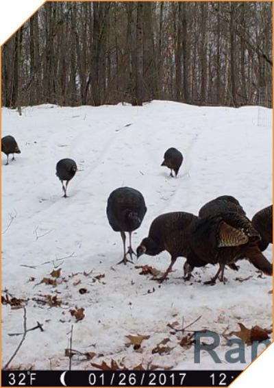
We placed the last oats in the Oak Meadow, EastEnd and Lenise's Stand, before Spring Turkey season. We’re certain it will be all gone long before the season starts on April 12th. We swapped out the memory cards and found more interesting images, check them out. On one of the camera we saw a wounded deer. We'll be contacting the local DNR Office and ask what could be done. We GPS'd a few locations so we could get them actually placed on the plat map. Kip slipped and fell onto the veranda from an icy spot in front of the new cabin. He bruised three ribs and strained both shoulders, but he did manage to save his knees. We looked through many images, about 5000. On two of the images we saw a bobcat kit. How did we know it was a kit? Two hours earlier, some turkeys wondered through the same place. The bobcat is about half the size of the turkeys. Speaking of turkeys, we are guesstimating there are about 60 to 70 turkeys on the property and at least three distinct flocks: a flock of toms and jakes - ~10; a flock of hens and poults - ~20+; and a flock with the dominate tom and a big mess of hens - ~30 - 40.We saw no sign or images of bear this time around. It's also been a lot colder of late. There are images of a coyote carefully smelling its way through the Oak Meadow. There's a whole ton of squirrels, including two black squirrels in the Oak Meadow, EastEnd and Lenise's Stand. Exploring and I Get LostSaturday 18 March 2017
Kip was still recovering from his fall at the cabin, so I went up on my own. I left fairly early in the morning, hoping to be back around noon to review the images from all the memory cards. Just before the turn off to the property, I noticed the gate was missing from a dirt road on the south side. I was curious about what was there. The St Croix State Forest and Ojibwa land borders the road and I hoped I would find way to cross the creek and end up a little farther down the road near the property. The dirt road followed the creek and I carefully read the signs that were posted; Ojibwa Land, no hunting, trapping, camping - nothing about no trespassing. I followed the road in about a mile and came to a creek crossing. The crossing had the boardwalk removed, so the road disappeared into the creek and reappeared on the other side. One side of the road drop away into water about four feet deep and other side into boulder filled water about two to three feet deep. Where the boardwalk once had been, there melon sized boulders and water about a foot deep. I was reluctant to cross, because the angle of attack on both sides of the crossing looked too steep for the Ranger…I did it anyway. Once on the other side of the creek and up a small hill, I found the forest there had been cleared of almost all the trees. The only trees left standing where young sugar maples and oaks, everything had been forestry mulched. There were remnants of a road I followed, thinking I was heading north. The "road" was more ruts, large divots and holes and the mostly treeless gap, zig-zagged along the border of mulched and not mulched forest. I drove until I came to a wide deeply rutted spot that ran about 100 yards. I walked another 200 yards or so and came upon an ATV/Snowmobile trail. I was very excited, but I realized those trails were much farther in the St Croix Forest than where I thought I was. I pulled out Kip's GPS and look at it again; I was heading south, not north. I had driven a little over 3/4 of a mile in the wrong direction. I pulled up the St Croix Forest trail map on my phone and found I was nearly a mile and half from where I thought I was. I headed back the way I came. It was slow going and the round trip took over two and half hours. As I neared County Road 48, I noticed huge piles of slashings and several large white pine trees nicked and scraped about ten to twelve feet off the ground. I realized that whatever machinery was back in here was huge. I also noticed the entry gate to this road had been completely removed, posts and all. I finally made onto the property about 10:45am, about the time I thought I would be heading back home. As I went to collect the memory cards, there were many trees down on the property; a few across the roads. Luckily, I didn't have to use the chainsaw or logging chains to move any of the downed trees. In the Oak Meadow there was a lot of evidence of bears wandering through, mostly bear scat. I was hoping the cameras caught a few images of bears. I was glad I had brought along bear spray. There was so much bear and deer scat where the ground blind had before, I called Kip and asked if he wanted the blind in the same place. We agreed placing the blind in another location would be best. I placed the blind on the east side of the meadow. The ground was still frozen, so I was unable to place stakes to hold it in place. I tied the blind off to a couple of nearby trees. Surprisingly, there were a few recently made deer scraps; I saw three in fact. Lots of turkey scratchings and squirrel burrowings. The cattle mineral blocks in both locations were well used. The Meadows were replete with all sort of wildlife activity. We would find out later, from the images caught on the trail cams, that all sorts of animals like these particular mineral blocks, including birds.
Journal Archives
2019
• June • September • October2018
• January • June • August • September • October2017
• January • February • March2016
• February • March • April • June • September • October • November2015
• June • November


© Copyrights 1988, 1990-1999, 2000-2006, 2010-2020
Rankton LLC

Journal 2017 Archive
January 2017
More Feed Out in the ColdSunday 1 January 2017
On Friday, I purchased 200 lbs of feed to throw around. I purchased 100 lbs of oats, 50 lbs of All Stock and 50 lbs of All Flock from Fleet Farm's Sprout brand feeds. Kip and I wondered what the different feeds would attract. We had thrown down some All Stock in the Cabin Meadow two winters ago, and it was eaten up by many different critters. Along with it being one of the coldest days in the past few weeks, the snow was relatively deep, averaging about a foot and half. The undercarriage of the Ford Ranger made troughs on the road. I put All Flock, All Stock and oats near the cameras in the East End, Lenise's Stand and the Oak Meadow. I made 'food troughs' with the tires on the Ranger by driving back and forth in the deep snow. I hoped to acclimatize the deer to the smell of the truck; not necessarily having the deer associating the truck with food, but knowing that when the truck is around, it didn't mean any harm. We're excited to see what the cameras capture.February 2017
Trails Cams with nearly 10,000 imagesSaturday 4 February 2017
We've be sick with what ever is going around. Since I was feeling the better of the two of us, I made the run to swap out memory cards. The cameras had stayed out for over 5 weeks and collected lots of pictures; nearly 10,000 in total. Some of the cameras even registered more images than the SD cards should have been able to hold and yes, that's how many were on the cards. I put out feed, oats, flock and stock pellets, on the 13JAN and it attracted a lot of critters! The Widow Maker Corner camera captured some interesting images. Rankton9, in Roy’s Loop, captured some good images of one of the bobcats. Gallery SnafuWednesday 8 February 2017
Kip showed me that there was something wrong with the abZorba Gallery. It had lost all the configurations and customizations that I had done. It was late in the evening and I decided I would work on the issue on Friday. Gallery Snafu Continues…Friday 10 February 2017
I spent the day trying to fix the abZorba Gallery and found out a lot of interesting information regarding the gallery application, jAlbum. I won't bore you with all the details. Suffice to say, after updating the Skin (this gives the gallery its look and feel) and the application, the gallery was still broken. I'm suspecting we have reached the image and video limit of the application or Skin. There are over 6,000 images and 200 videos in the gallery. I was able to recover an older version of the gallery and post that back to the website. So for now, the most recent images are from early December 2016. More Feed for the WinterSaturday 11 February 2017
We put out more feed, this time just oats and All Flock; 100lb of each. We divided the 100lbs into 6 cat litter buckets of around 30 to 35 lbs each. We placed two buckets of each at the East End, one bucket of each near my stand, and three buckets of each in the Oak Meadow. We moved two of the cameras; the one on the road to Oak Meadow and the one between the EastEnd Loop and Lenise's Stand. We placed one pointing up a heavily used trail that crosses the road near the Knoll. The other we placed pointing across the dam near the new cabin. There's not a lot of activity evident there, but we're interested to see what is wandering near the new cabin. We also reviewed, discussed and prioritized a large portion of the projects we have planned for this year. Quick Trip to Swap MemoryFriday 17 February 2017
I went on a quick trip to memory swap the cameras, but I forgot to swap the memory of the camera in Roy's shooting lane. The roads at the property were icy and someone had thrown down shingles on the sloped road up to the cabin. I had no trouble going up the sloped road in 4WD with the Ranger, though I didn't drive the truck up the road to my stand. I filled my phone with pictures and video; we’ll have those posted in Gallery soon. I thought of the idea to use perfume scents as cover and attractant scents for hunting. I found some cool scent ideas. Kip and I will be discussing these ideas some more. March 2017 Camera Images & Last Winter FeedSaturday 4 March 2017
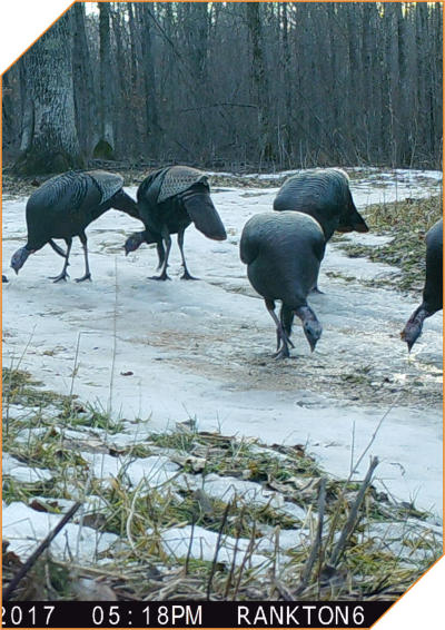
We placed the last oats in the Oak Meadow, EastEnd and Lenise's Stand, before Spring Turkey season. We’re certain it will be all gone long before the season starts on April 12th. We swapped out the memory cards and found more interesting images, check them out. On one of the camera we saw a wounded deer. We'll be contacting the local DNR Office and ask what could be done. We GPS'd a few locations so we could get them actually placed on the plat map. Kip slipped and fell onto the veranda from an icy spot in front of the new cabin. He bruised three ribs and strained both shoulders, but he did manage to save his knees. We looked through many images, about 5000. On two of the images we saw a bobcat kit. How did we know it was a kit? Two hours earlier, some turkeys wondered through the same place. The bobcat is about half the size of the turkeys. Speaking of turkeys, we are guesstimating there are about 60 to 70 turkeys on the property and at least three distinct flocks: a flock of toms and jakes - ~10; a flock of hens and poults - ~20+; and a flock with the dominate tom and a big mess of hens - ~30 - 40.We saw no sign or images of bear this time around. It's also been a lot colder of late. There are images of a coyote carefully smelling its way through the Oak Meadow. There's a whole ton of squirrels, including two black squirrels in the Oak Meadow, EastEnd and Lenise's Stand. Exploring and I Get LostSaturday 18 March 2017
Kip was still recovering from his fall at the cabin, so I went up on my own. I left fairly early in the morning, hoping to be back around noon to review the images from all the memory cards. Just before the turn off to the property, I noticed the gate was missing from a dirt road on the south side. I was curious about what was there. The St Croix State Forest and Ojibwa land borders the road and I hoped I would find way to cross the creek and end up a little farther down the road near the property. The dirt road followed the creek and I carefully read the signs that were posted; Ojibwa Land, no hunting, trapping, camping - nothing about no trespassing. I followed the road in about a mile and came to a creek crossing. The crossing had the boardwalk removed, so the road disappeared into the creek and reappeared on the other side. One side of the road drop away into water about four feet deep and other side into boulder filled water about two to three feet deep. Where the boardwalk once had been, there melon sized boulders and water about a foot deep. I was reluctant to cross, because the angle of attack on both sides of the crossing looked too steep for the Ranger…I did it anyway. Once on the other side of the creek and up a small hill, I found the forest there had been cleared of almost all the trees. The only trees left standing where young sugar maples and oaks, everything had been forestry mulched. There were remnants of a road I followed, thinking I was heading north. The "road" was more ruts, large divots and holes and the mostly treeless gap, zig-zagged along the border of mulched and not mulched forest. I drove until I came to a wide deeply rutted spot that ran about 100 yards. I walked another 200 yards or so and came upon an ATV/Snowmobile trail. I was very excited, but I realized those trails were much farther in the St Croix Forest than where I thought I was. I pulled out Kip's GPS and look at it again; I was heading south, not north. I had driven a little over 3/4 of a mile in the wrong direction. I pulled up the St Croix Forest trail map on my phone and found I was nearly a mile and half from where I thought I was. I headed back the way I came. It was slow going and the round trip took over two and half hours. As I neared County Road 48, I noticed huge piles of slashings and several large white pine trees nicked and scraped about ten to twelve feet off the ground. I realized that whatever machinery was back in here was huge. I also noticed the entry gate to this road had been completely removed, posts and all. I finally made onto the property about 10:45am, about the time I thought I would be heading back home. As I went to collect the memory cards, there were many trees down on the property; a few across the roads. Luckily, I didn't have to use the chainsaw or logging chains to move any of the downed trees. In the Oak Meadow there was a lot of evidence of bears wandering through, mostly bear scat. I was hoping the cameras caught a few images of bears. I was glad I had brought along bear spray. There was so much bear and deer scat where the ground blind had before, I called Kip and asked if he wanted the blind in the same place. We agreed placing the blind in another location would be best. I placed the blind on the east side of the meadow. The ground was still frozen, so I was unable to place stakes to hold it in place. I tied the blind off to a couple of nearby trees. Surprisingly, there were a few recently made deer scraps; I saw three in fact. Lots of turkey scratchings and squirrel burrowings. The cattle mineral blocks in both locations were well used. The Meadows were replete with all sort of wildlife activity. We would find out later, from the images caught on the trail cams, that all sorts of animals like these particular mineral blocks, including birds.
Journal Archives
2019
• June • September • October2018
• January • June • August • September • October2017
• January • February • March2016
• February • March • April • June • September • October • November2015
• June • November